File:View of Vicksburg.jpg
原始文件 (6,552 × 5,024像素,文件大小:4.94 MB,MIME类型:image/jpeg)
摘要
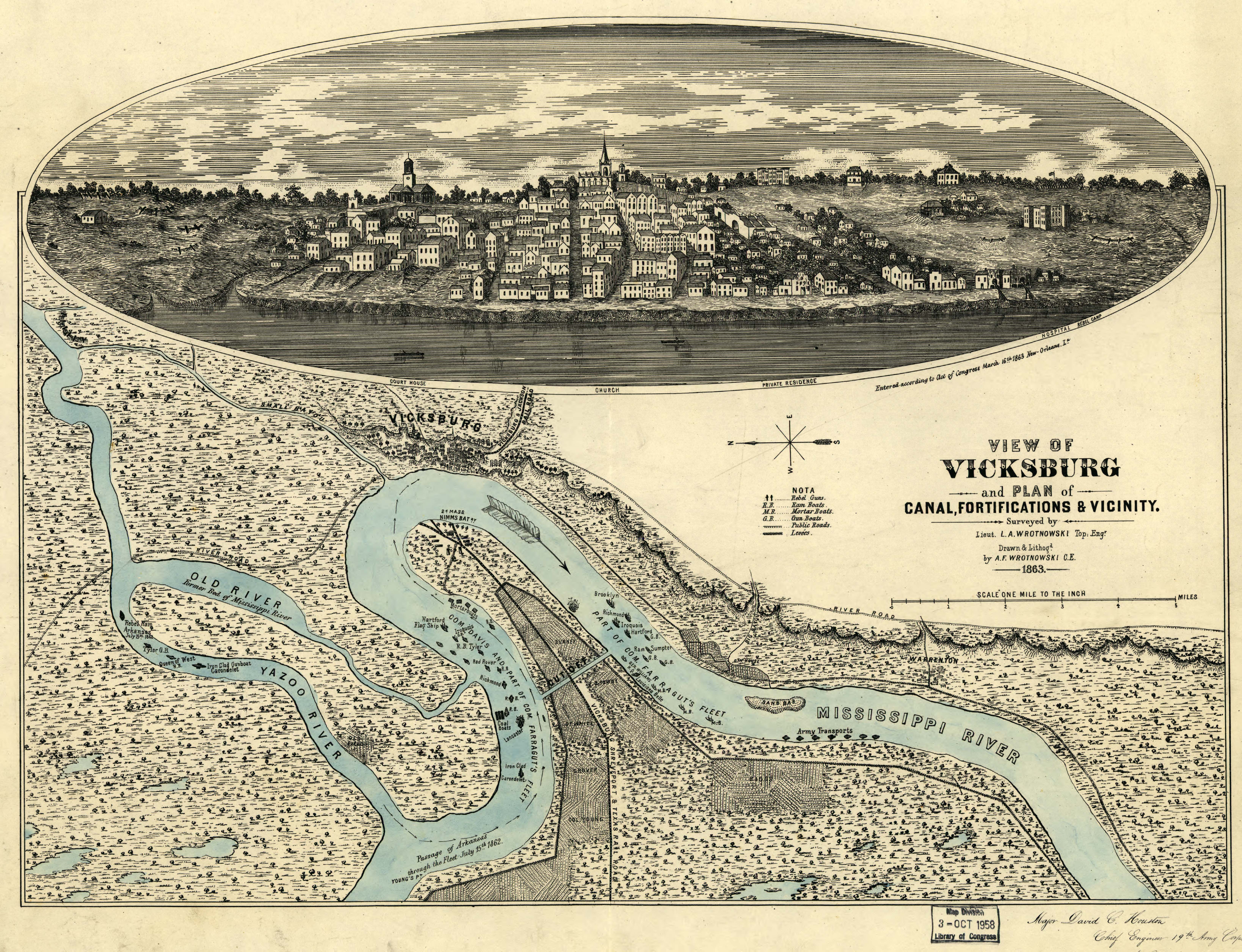
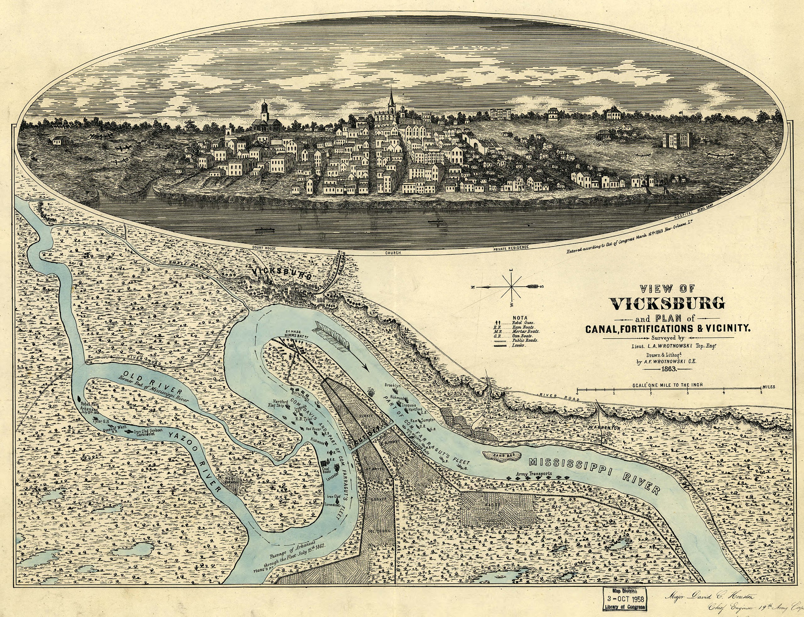
View of Vicksburg, Mississippi, 1863, during the American Civil War
Original work
View of Vicksburg and plan of the canal, fortifications & vicinity Surveyed by Lieut. L. A. Wrotnowski, Top: Engr. Drawn & lithogd. by A. F. Wrotnowski C.E.
Wrotnowski, L. A.
CREATED/PUBLISHED[S.l.], 1863.
NOTESScale 1:63,360.
Reference: LC Civil War Maps (2nd ed.), 294
Indicates fortifications, location, type and names of boats, roads, railroads, levees, drainage, vegetation, and the names of a few residents.
Inset: [View of Vicksburg] 17 x 54 cm.
Inscribed in the lower right hand corner "Major David C. Houston, Chief Engineer, 19th Army Corps, with the compliments from the author."
Description derived from published bibliography.
SUBJECTSVicksburg (Miss.)--History--Civil War, 1861-1865--Maps.United States--Mississippi--Vicksburg.
MEDIUM1 view, col., 40 x 54 cm.
CALL NUMBERG3984.V8S5 1863 .W7 CW 294
REPOSITORYLibrary of Congress Geography and Map Division Washington, D.C. 20540-4650
DIGITAL IDg3984v cw0294000 http://hdl.loc.gov/loc.gmd/g3984v.cw0294000
许可协议
 |
文件历史
点击某个日期/时间查看对应时刻的文件。
| 日期/时间 | 缩略图 | 大小 | 用户 | 备注 | |
|---|---|---|---|---|---|
| 当前 | 2007年8月2日 (四) 23:57 | | 6,552 × 5,024(4.94 MB) | Kkmurray | ==Original work== [http://lcweb2.loc.gov/cgi-bin/query/r?ammem/aaodyssey,gmd,fmuever,mmorse,upboverbib:@field(NUMBER+@band(g3984v+cw0294000))] View of Vicksburg and plan of the canal, fortifications & vicinity Surveyed by Lieut. L. A. Wrotnowski, Top: E |
文件用途
以下页面使用本文件:
全域文件用途
以下其他wiki使用此文件:
- azb.wikipedia.org上的用途
- da.wikipedia.org上的用途
- en.wikipedia.org上的用途
- fa.wikipedia.org上的用途
- fr.wikipedia.org上的用途
- he.wikipedia.org上的用途
- hu.wikipedia.org上的用途
- ja.wikipedia.org上的用途
- nl.wikipedia.org上的用途
- pl.wikipedia.org上的用途
- sh.wikipedia.org上的用途