

原始文件 (1,200 × 715像素,文件大小:510 KB,MIME类型:image/png)
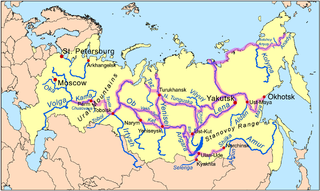
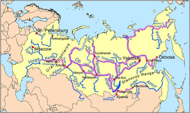
| 描述Siberiariverroutemap.png | This is a map of the Siberian River Routes. | ||
| 日期 | |||
| 来源 | Own work using Digital Chart of the World data. Routes based on descriptions from Forsyth, James, "A History of the Peoples of Siberia",1992. | ||
| 作者 | Kmusser | ||
| 其他版本 |
|
点击某个日期/时间查看对应时刻的文件。
| 日期/时间 | 缩略图 | 大小 | 用户 | 备注 | |
|---|---|---|---|---|---|
| 当前 | 2009年11月30日 (一) 15:13 | | 1,200 × 715(510 KB) | Kmusser | extend NE route, add Stanovoy label |
| 2009年11月24日 (二) 18:32 |  | 1,200 × 715(503 KB) | Kmusser | Added route in far NE. | |
| 2009年1月5日 (一) 21:34 |  | 1,200 × 715(492 KB) | Kmusser | corrections to Amur route | |
| 2008年11月18日 (二) 14:15 |  | 1,200 × 715(490 KB) | Kmusser | added Ural label | |
| 2008年11月17日 (一) 21:57 |  | 1,000 × 596(378 KB) | Kmusser | Expanded | |
| 2008年11月12日 (三) 20:34 |  | 800 × 477(258 KB) | Kmusser | {{Information |Description=This is a map of the Siberian River Routes. |Source=Own work using http://www.maproom.psu.edu/dcw/ Digital Chart of the World data. |Date=November 12, 2008 |Author=Kmusser |Perm |
以下其他wiki使用此文件:
查看本文件的更多全域用途。
