File:Schlieffen Plan.jpg

原始文件 (963 × 745像素,文件大小:732 KB,MIME类型:image/jpeg)
 | File:Schlieffen Plan fr.svg是此文件的矢量版本。 如果此文件质量不低于原点阵图,就应该将这个JPG格式文件替换为此文件。 File:Schlieffen Plan.jpg → File:Schlieffen Plan fr.svg 更多信息请参阅Help:SVG/zh。 |  |
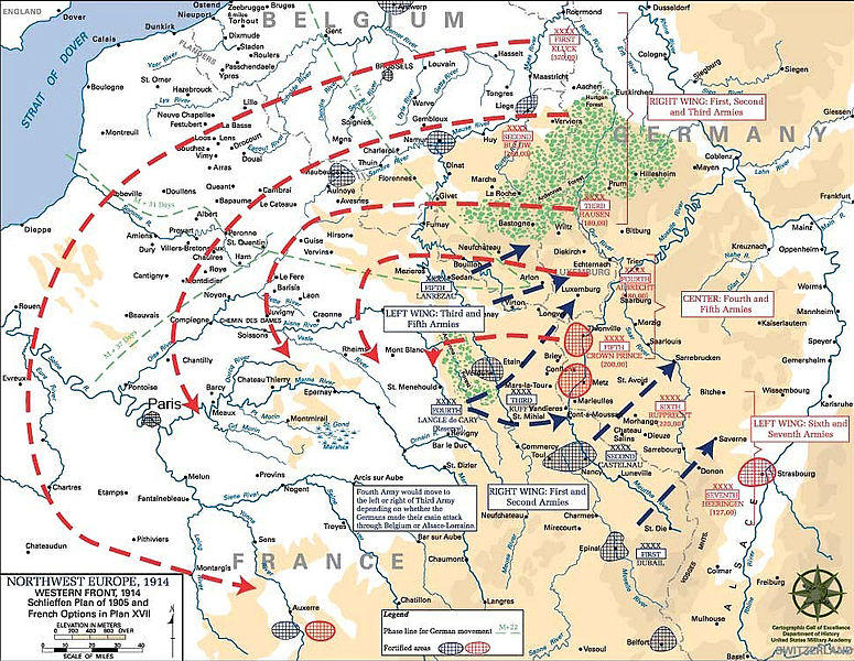
| 描述 | English: Schlieffen Plan
In 1938 the predecessors of what is today The Department of History at the United States Military Academy began developing a series of campaign atlases to aid in teaching cadets a course entitled, "History of the Military Art." Since then, the Department has produced over six atlases and more than one thousand maps, encompassing not only America’s wars but global conflicts as well. In keeping abreast with today's technology, the Department of History is providing these maps on the internet as part of the department's outreach program. The maps were created by the United States Military Academy’s Department of History and are the digital versions from the atlases printed by the United States Defense Printing Agency. We gratefully acknowledge the accomplishments of the department's former cartographer, Mr. Edward J. Krasnoborski, along with the works of our present cartographer, Mr. Frank Martini. Please be aware that these maps are large in file size and may require substantial download times. |
| 日期 | 05/09/2008 |
| 来源 | Westpoint.edu, WWI Atlas, Shlieffen Plan |
| 作者 | Tinodela |
| 其他版本 | |
 |
Derivative works
此文件衍生的作品: Schlieffen Plan.svg
文件历史
点击某个日期/时间查看对应时刻的文件。
| 日期/时间 | 缩略图 | 大小 | 用户 | 备注 | |
|---|---|---|---|---|---|
| 当前 | 2012年7月23日 (一) 11:43 | | 963 × 745(732 KB) | Soerfm | Paris |
| 2006年3月1日 (三) 11:58 |  | 969 × 751(273 KB) | W.wolny |
文件用途
全域文件用途
以下其他wiki使用此文件:
- ar.wikipedia.org上的用途
- be-tarask.wikipedia.org上的用途
- be.wikipedia.org上的用途
- bg.wikipedia.org上的用途
- ca.wikipedia.org上的用途
- cs.wikipedia.org上的用途
- da.wikipedia.org上的用途
- de.wikipedia.org上的用途
- de.wikibooks.org上的用途
- de.wikinews.org上的用途
- el.wikipedia.org上的用途
- en.wikipedia.org上的用途
- en.wikibooks.org上的用途
- fi.wikipedia.org上的用途
- fr.wikipedia.org上的用途
查看本文件的更多全域用途。