File:MD36 near I-68 in Frostburg.jpg

本预览的尺寸:800 × 533像素。 其他分辨率:320 × 213像素 | 640 × 427像素 | 1,024 × 683像素 | 1,500 × 1,000像素。
原始文件 (1,500 × 1,000像素,文件大小:249 KB,MIME类型:image/jpeg)
摘要
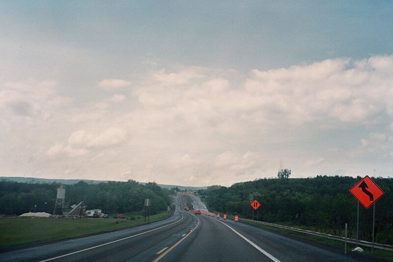
| 描述 | English: Photograph of w:Maryland Route 36 between w:Maryland Route 55 and w:Interstate 68 south of w:Frostburg, Maryland. As of spring 2008, the four-lane section of Route 36 is narrowed to two lanes while repair work is done on the I-68 overpass. |
| 来源 | 自己的作品 |
| 作者 | Algorerhythms |
| 相机位置 | | 在以下服务上查看本图像和附近其他图像: OpenStreetMap |
|---|
许可协议
我,本作品著作权人,特此采用以下许可协议发表本作品:
本文件采用知识共享署名-相同方式共享 3.0 未本地化版本许可协议授权。
- 您可以自由地:
- 共享 – 复制、发行并传播本作品
- 修改 – 改编作品
- 惟须遵守下列条件:
- 署名 – 您必须对作品进行署名,提供授权条款的链接,并说明是否对原始内容进行了更改。您可以用任何合理的方式来署名,但不得以任何方式表明许可人认可您或您的使用。
- 相同方式共享 – 如果您再混合、转换或者基于本作品进行创作,您必须以与原先许可协议相同或相兼容的许可协议分发您贡献的作品。
 | 已授权您依据自由软件基金会发行的无固定段落及封面封底文字(Invariant Sections, Front-Cover Texts, and Back-Cover Texts)的GNU自由文件许可协议1.2版或任意后续版本的条款,复制、传播和/或修改本文件。该协议的副本请见“GNU Free Documentation License”。 |
您可以选择您需要的许可协议。
文件历史
点击某个日期/时间查看对应时刻的文件。
| 日期/时间 | 缩略图 | 大小 | 用户 | 备注 | |
|---|---|---|---|---|---|
| 当前 | 2008年6月6日 (五) 00:12 | | 1,500 × 1,000(249 KB) | Algorerhythms | {{Information |Description={{en|1=Photograph of w:Maryland Route 36 between w:Maryland Route 55 and w:Interstate 68 south of w:Frostburg, Maryland. As of spring 2008, the four-lane section of Route 36 is narrowed to two lanes while repair |
文件用途
以下页面使用本文件:
全域文件用途
以下其他wiki使用此文件:
- simple.wikipedia.org上的用途
元数据
🔥 Top keywords: Baike: 首页Special:搜索国际劳动节淚之女王劳动节九龍城寨之圍城2024年湯姆斯盃2024年優霸盃不夠善良的我們背着善宰跑金智媛逆天奇案2春色寄情人金秀賢 (男演員)邊佑錫福建號航空母艦城市猎人 (2024年电影)梅龙高速公路习近平九龍寨城陳耀祥破墓城市猎人笑看風雲六四事件排球少年!!排球少年!!角色列表與鳳行承欢记Seventeen (組合)支配物种劉俊謙 (香港)許瑋甯ILLIT宁安如梦鈴木亮平BABYMONSTER孫綻媽祖中华人民共和国朴成焄周雨彤无用的谎言中華民國張文傑金惠奫周處除三害 (電影)赵长鹏怪獸8號BOYNEXTDOOR李主儐第二十条白鹿 (演員)國道三號崩塌事故澄碧邨乘風2024幕府將軍 (2024年電視劇)哈里·R·杜鲁门李美淑阿努纳奇比利小子特技玩家活塞男事件李现葬送的芙莉蓮IVE (組合)林依晨日本五月天帝國浩劫:美國內戰(G)I-DLEP站末日愚者夜限照相馆三流之路打天下2机动战士GUNDAM SEED FREEDOM張惠東草榴社区三体 (小说)香港鄧麗君迷宮飯NewJeansEnergy (組合)徐巧芯逆天奇案為美好的世界獻上祝福!姜濤搜查班長1958吉伊卡哇張書偉謝京穎艾爾頓·冼拿賀軍翔毛泽东少年歌行轉生為第七王子,隨心所欲的魔法學習之路木村文乃