File:Katrina-new-orleans-flooding3-2005.jpg
本预览的尺寸:800 × 600像素。 其他分辨率:320 × 240像素 | 640 × 480像素 | 1,024 × 768像素 | 1,280 × 960像素 | 1,600 × 1,200像素。
原始文件 (1,600 × 1,200像素,文件大小:1.05 MB,MIME类型:image/jpeg)
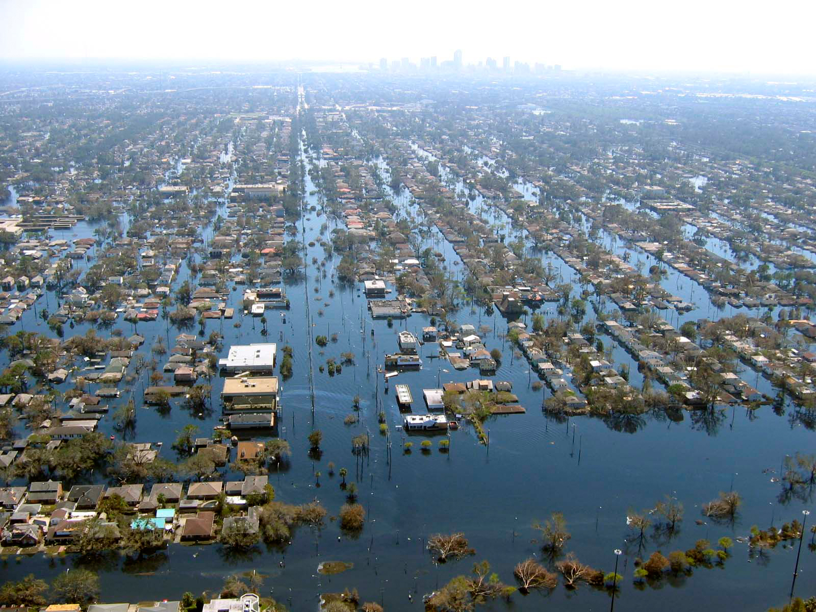
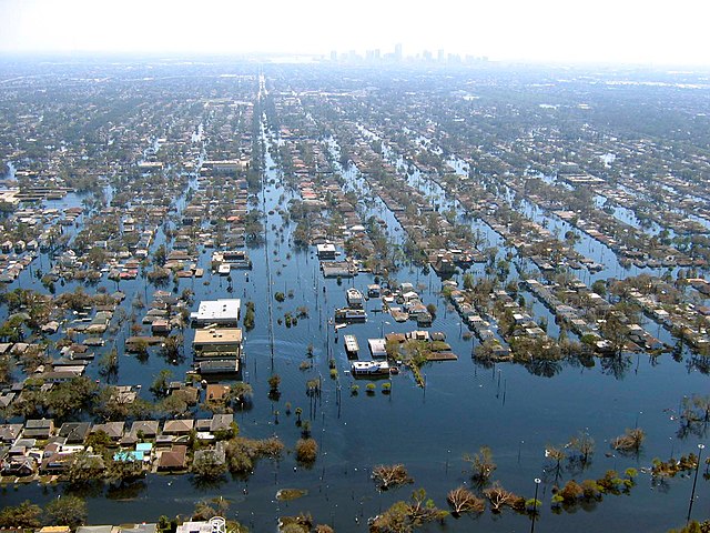
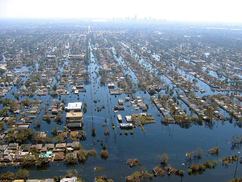
| 描述 | View of flooded New Orleans, Louisiana in the aftermath of Hurricane Katrina | |||
| 日期 | ||||
| 来源 | http://www.katrina.noaa.gov/helicopter/helicopter-2.html | |||
| 作者 | Commander Mark Moran, of the NOAA Aviation Weather Center, and Lt. Phil Eastman and Lt. Dave Demers, of the NOAA Aircraft Operations Center, all commissioned officers of the NOAA Corps, flew more than 100 hours surveying Katrina’s devastation. Eastman piloted NOAA’s Bell 212 Twin Huey Helicopter from August 31 to September 19. All three men took dozens of aerial photos from an altitude of several feet to 500 feet. | |||
| 授权 (二次使用本文件) |
|
文件历史
点击某个日期/时间查看对应时刻的文件。
| 日期/时间 | 缩略图 | 大小 | 用户 | 备注 | |
|---|---|---|---|---|---|
| 当前 | 2008年4月22日 (二) 22:10 | | 1,600 × 1,200(1.05 MB) | Mfield | {{Information |Description=View of flooded New Orleans, Louisiana in the aftermath of Hurricane Katrina |Source=http://www.katrina.noaa.gov/helicopter/helicopter-2.html |Date=11 Sept 2005 |Author=Commander Mark Moran, of the NOAA Aviation Weather Center, |
| 2008年4月22日 (二) 22:07 |  | 1,600 × 1,200(264 KB) | Mfield | {{Information |Description=View of flooded New Orleans, Louisiana in the aftermath of Hurricane Katrina |Source=http://www.katrina.noaa.gov/helicopter/helicopter-2.html |Date=11 Sept 2005 |Author=Commander Mark Moran, of the NOAA Aviation Weather Center, |
文件用途
以下3个页面使用本文件:
全域文件用途
以下其他wiki使用此文件:
- bn.wikipedia.org上的用途
- de.wikipedia.org上的用途
- dty.wikipedia.org上的用途
- en.wikipedia.org上的用途
- et.wikipedia.org上的用途
- eu.wikipedia.org上的用途
- fa.wikipedia.org上的用途
- fr.wikipedia.org上的用途
- hy.wikipedia.org上的用途
- id.wikipedia.org上的用途
- ig.wikipedia.org上的用途
- pl.wikipedia.org上的用途
- pt.wikipedia.org上的用途
- ru.wikipedia.org上的用途
- sk.wikipedia.org上的用途
- sv.wikipedia.org上的用途
- sw.wikipedia.org上的用途
- tr.wikipedia.org上的用途
- uk.wikipedia.org上的用途
- ur.wikipedia.org上的用途
元数据
🔥 Top keywords: Baike: 首页淚之女王Special:搜索不夠善良的我們2024年湯姆斯盃金智媛2024年優霸盃金秀賢 (男演員)春色寄情人破墓怪獸8號乘風2024城市猎人排球少年!!背着善宰跑习近平承欢记張敬軒排球少年!!角色列表九龍城寨之圍城逆天奇案2BABYMONSTER六四事件ILLIT許瑋甯李主儐末日愚者與鳳行朴成焄鈴木亮平BOYNEXTDOOR方皓玟周處除三害 (電影)馬陸李美淑Seventeen (組合)崔永元完全省錢戀愛手冊921大地震机动战士GUNDAM SEED FREEDOM第二十条搜查班長1958NewJeans迷宮飯中華民國中华人民共和国林依晨愛的迫降葬送的芙莉蓮幕府將軍 (2024年電視劇)田馥甄三体 (小说)Energy (組合)(G)I-DLE傅崐萁周雨彤Believe-為你架起的橋樑-無職轉生~到了異世界就拿出真本事~Hide (电视剧)劉偉健劍星日本特技玩家徐譽庭郭東延黃道十二宮寄生獸:灰色部隊賀軍翔2024年花蓮地震支配物种朴智恩 (編劇)半生緣 (電影)HYBE邊佑錫WIND BREAKER—防風少年—柯震東香港來自星星的你宁安如梦鄭靚歆尹普美毛泽东白鹿 (演員)無職轉生~到了異世界就拿出真本事~角色列表戀愛兄妹草榴社区我獨自升級安東尼·布林肯李现LE SSERAFIM金秀賢影視作品列表少年歌行臧芮軒三流之路满城尽带黄金甲金正蘭但願人長久 (電影)国际劳动节P站