File:Himalayan Tectonic Summary.png
本预览的尺寸:800 × 519像素。 其他分辨率:320 × 207像素 | 640 × 415像素 | 1,024 × 664像素 | 1,280 × 830像素 | 2,658 × 1,723像素。
原始文件 (2,658 × 1,723像素,文件大小:729 KB,MIME类型:image/png)
摘要
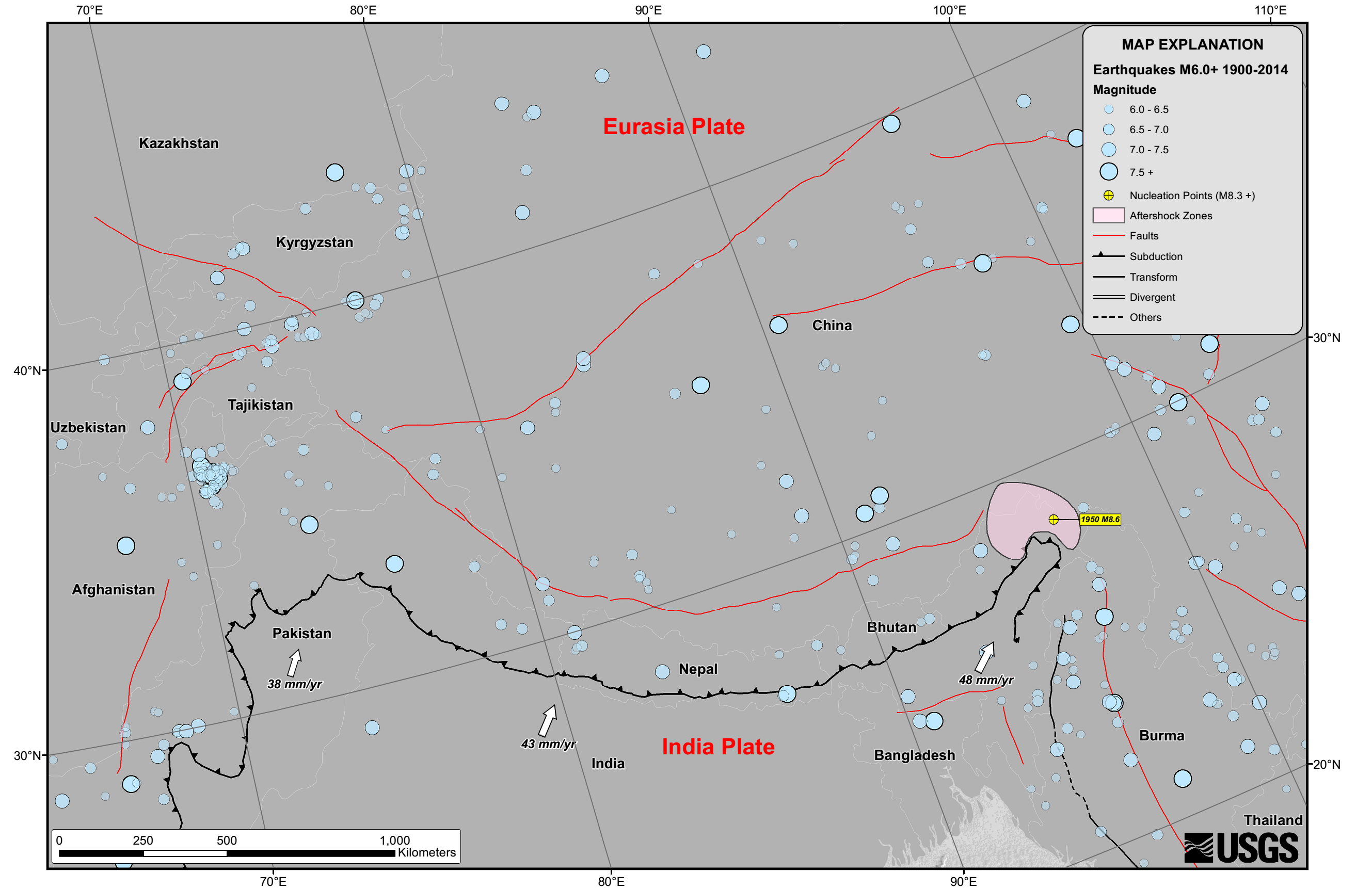
| 描述 | English: Seismicity in the Himalaya dominantly results from the continental collision of the India and Eurasia plates, which are converging at a relative rate of 40-50 mm/yr. Northward underthrusting of India beneath Eurasia generates numerous earthquakes and consequently makes this area one of the most seismically hazardous regions on Earth. The surface expression of the plate boundary is marked by the foothills of the north-south trending Sulaiman Range in the west, the Indo-Burmese Arc in the east and the east-west trending Himalaya Front in the north of India. |
| 日期 | |
| 来源 | https://earthquake.usgs.gov/earthquakes/tectonic/images/himalaya_tsum.pdf |
| 作者 | United States Geological Survey |
许可协议
文件历史
点击某个日期/时间查看对应时刻的文件。
| 日期/时间 | 缩略图 | 大小 | 用户 | 备注 | |
|---|---|---|---|---|---|
| 当前 | 2015年4月26日 (日) 10:53 | | 2,658 × 1,723(729 KB) | Tatiraju.rishabh | User created page with UploadWizard |
文件用途
以下页面使用本文件:
全域文件用途
以下其他wiki使用此文件:
- af.wikipedia.org上的用途
- ar.wikipedia.org上的用途
- awa.wikipedia.org上的用途
- be.wikipedia.org上的用途
- en.wikipedia.org上的用途
- es.wikipedia.org上的用途
- hi.wikipedia.org上的用途
- nl.wikipedia.org上的用途
- pnb.wikipedia.org上的用途
- ru.wikipedia.org上的用途
- sl.wikipedia.org上的用途
- ta.wikipedia.org上的用途
- tg.wikipedia.org上的用途
- ur.wikipedia.org上的用途
元数据
🔥 Top keywords: Baike: 首页Special:搜索胖猫跳江事件背着善宰跑九龍城寨之圍城逆天奇案2璩静淚之女王歌手2024Energy (組合)新生 (网络剧)习近平匈牙利邊佑錫劉俊謙 (香港)金智媛神耆小子塞尔维亚金秀賢 (男演員)母亲节猩球崛起:王國誕生九龍寨城馴鹿寶貝家族榮耀之繼承者Seventeen (組合)六四事件不夠善良的我們张维为楊佩潔TripleS支配物种庆余年郭葦昀洪若潭命案金惠奫2024年英雄联盟季中邀请赛春色寄情人BABYMONSTER笑看風雲乘風2024排球少年!!角色列表破墓徐巧芯中华人民共和国中華民國打天下2WIND BREAKER—防風少年—习明泽排球少年!!彭丽媛磁暴ILLIT贾斯汀·比伯逆天奇案BOYNEXTDOOR猿人爭霸戰:猩凶革命張書偉我的婆婆怎麼那麼可愛我獨自升級怪獸8號謝坤達IVE (組合)與鳳行關於我轉生變成史萊姆這檔事角色列表黃道十二宮福建號航空母艦虽然不是英雄葉乃文五月天張員瑛草榴社区張文傑2024年花蓮地震极光香緹·摩爾迷宮飯呂家愷搜查班長1958日本劉德華海莉·鮑德溫蕭景鴻越位 (足球)葬送的芙莉蓮周處除三害 (電影)毛泽东願榮光歸香港林峯周雨彤伍允龍羅毓儀香港Baike: 分類索引沒有秘密猩球崛起:終極決戰角質層唐振剛柯佳嬿文化大革命