File:Europe before Operation Barbarossa, 1941 (in German).png

本预览的尺寸:575 × 599像素。 其他分辨率:230 × 240像素 | 461 × 480像素 | 958 × 998像素。
原始文件 (958 × 998像素,文件大小:142 KB,MIME类型:image/png)
摘要
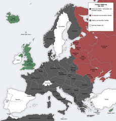
| 描述 | English: Map showing the Nazi, Finnish and Soviet-controlled borders of Europe by the end of May/beginning of June 1941, by the conclusion of the Nazi invasion of the Balkans and before Operation Barbarossa.This PNG image, with captions in German, is derived from a frame from the GIF animation File:Second world war europe animation large de.gif at Wikimedia Commons. |
| 日期 | 2010年4月7日 (原始上传日期) |
| 来源 | 本檔案是從en.wikipedia轉移到維基共享資源。 |
| 作者 | Later version(s) were uploaded by DIREKTOR at en.wikipedia. |
| 其他版本 |
|
.png)
.png#file)
.png#filehistory)
.png#filelinks)
.png#globalusage)
.png#metadata)
许可协议
 | 已授权您依据自由软件基金会发行的无固定段落及封面封底文字(Invariant Sections, Front-Cover Texts, and Back-Cover Texts)的GNU自由文件许可协议1.2版或任意后续版本的条款,复制、传播和/或修改本文件。该协议的副本请见“GNU Free Documentation License”。 |
| 本文件采用知识共享署名-相同方式共享 3.0 未本地化版本许可协议授权。 | ||
| ||
| 本许可协议标签作为GFDL许可协议更新的组成部分被添加至本文件。 |
原始上传日志
原始描述頁面位於這裡。下列使用者名稱均來自en.wikipedia。
- 2012-05-22 17:09 DIREKTOR 958×998× (200029 bytes) Colours
- 2010-04-07 01:43 MaGioZal 960×1000× (149500 bytes) Map showing the Nazi (darker blue) and Soviet-controlled (green) borders of Europe by the end of May/beginning of June [[1941]], after the [[Balkans Campaign|Nazi invasion of the Balkans]] and before [[Operation Barbarossa]]. This [[PNG image]], with cap
文件历史
点击某个日期/时间查看对应时刻的文件。
| 日期/时间 | 缩略图 | 大小 | 用户 | 备注 | |
|---|---|---|---|---|---|
| 当前 | 2012年9月7日 (五) 18:13 | | 958 × 998(142 KB) | Illythr | Removed the "changes in the last frame" coloring, as there's only one frame here and the legend was misleading. |
| 2012年8月16日 (四) 02:09 |  | 958 × 998(195 KB) | OgreBot | (BOT): Reverting to most recent version before archival | |
| 2012年8月16日 (四) 02:09 |  | 960 × 1,000(146 KB) | OgreBot | (BOT): Uploading old version of file from en.wikipedia; originally uploaded on 2010-04-07 01:43:08 by MaGioZal | |
| 2012年6月22日 (五) 20:04 |  | 958 × 998(195 KB) | Friedlibend und tapfer | {{Information |Description={{en|Map showing the Nazi and Soviet-controlled borders of Europe by the end of May/beginning of June 1941, by the conclusion of the Nazi invasion of the Balkans and before [[:en:Operatio... |
文件用途
全域文件用途
以下其他wiki使用此文件:
- af.wikipedia.org上的用途
- ar.wikipedia.org上的用途
- ast.wikipedia.org上的用途
- azb.wikipedia.org上的用途
- az.wikipedia.org上的用途
- bg.wikipedia.org上的用途
- bn.wikipedia.org上的用途
- br.wikipedia.org上的用途
- ca.wikipedia.org上的用途
- cs.wikipedia.org上的用途
- en.wikipedia.org上的用途
- Continuation War
- Molotov–Ribbentrop Pact
- Operation Barbarossa
- Eastern Front (World War II)
- Balkans campaign (World War II)
- Interim Peace
- User:Dead Mary/sandbox6
- User:Dead Mary/sandbox7
- Presidency of Franklin D. Roosevelt, third and fourth terms
- Foreign policy of the Franklin D. Roosevelt administration
- User:Falcaorib
- eo.wikipedia.org上的用途
- es.wikipedia.org上的用途
- fi.wikipedia.org上的用途
- hy.wikipedia.org上的用途
- lt.wikipedia.org上的用途
- lv.wikipedia.org上的用途
- nl.wikipedia.org上的用途
- pnb.wikipedia.org上的用途
- pt.wikipedia.org上的用途
- ru.wikipedia.org上的用途
- ta.wikipedia.org上的用途
- th.wikipedia.org上的用途
- ur.wikipedia.org上的用途
元数据
.png)
🔥 Top keywords: Baike: 首页Special:搜索毛泽东家族榮耀之繼承者天之驕女鐵拳英雄九龍城寨之圍城黃循財背着善宰跑篠崎泫妮妃雅新生 (网络剧)劉偉健斯洛伐克习近平劉俊謙 (香港)李显龙歌手2024佛誕淚之女王2024年泰國羽球公開賽新加坡總理邊佑錫新加坡Energy (組合)庆余年九龍寨城六四事件家族榮耀金智媛彌助菲律宾胖猫跳江事件劉寶傑DAY6林峯張文傑李光耀神耆小子張鳳妮黃世聰Seventeen (組合)维基百科願榮光歸香港中華民國鬼滅之刃 柱訓練篇2024年英雄联盟季中邀请赛中华人民共和国TripleS金秀賢 (男演員)罗伯特·菲佐井柏然2024年世界女排联赛黃偉哲怪獸8號佘詩曼Foodpanda金惠奫新加坡总统香緹·摩爾于北辰 (1968年)王嘉爾笑看風雲排球少年!!角色列表林飛帆郭葦昀馴鹿寶貝翁靜晶猩球崛起:王國誕生ILLIT尼古拉·約基奇春色寄情人周殷廷鬼滅之刃排球少年!!吳釗燮逆天奇案2不夠善良的我們BABYMONSTER李正皓尚达曼BOYNEXTDOOR胡子彤IVE (組合)陳靜 (香港)香港吴作栋黃道十二宮凡希亚·奥伊亚胡宇威長洲太平清醮張員瑛搜查班長1958伍允龍习明泽黄岩岛賴清德偶然遇見的你虽然不是英雄