File:Africa land cover location mamba map with borders.jpg

本预览的尺寸:635 × 600像素。 其他分辨率:254 × 240像素 | 508 × 480像素 | 813 × 768像素 | 1,084 × 1,024像素 | 1,525 × 1,440像素。
原始文件 (1,525 × 1,440像素,文件大小:928 KB,MIME类型:image/jpeg)
摘要
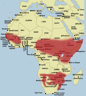
| 描述 | English: Map of geographical range of the black mamba in Africa. Source of information displayed is this or more specifically this linked file. | ||
| 日期 | March 12, 2019 based on earlier version published 2013年11月28日, 05:10:11 (上传日期); the source data displays a file modified date of March 22, 2013 | ||
| 来源 | File:Africa location map black mamba distribution.svg overlaid on File:Africa location map.svg | ||
| 作者 | Samsara using work by Sameboat and Sting | ||
| 授权 (二次使用本文件) |
本文件采用知识共享署名-相同方式共享 3.0 未本地化版本许可协议授权。
您可以选择您需要的许可协议。 |

文件历史
点击某个日期/时间查看对应时刻的文件。
| 日期/时间 | 缩略图 | 大小 | 用户 | 备注 | |
|---|---|---|---|---|---|
| 当前 | 2019年3月12日 (二) 21:01 | | 1,525 × 1,440(928 KB) | Samsara | {{Information |description ={{en|1=Map of geographical range of the black mamba in Africa. Source of information displayed is [http://www.toxinology.com/fusebox.cfm?fuseaction=main.snakes.display&id=SN0170 this] or more specifically [http://www.toxinology.com/images/snakes/SNMS0170.gif this linked file].}} |date =March 12, 2019 based on earlier version published {{Upload date|2013-11-28 05:10:11}}; the source data displays a file modified date of March 22, 2013 |source =[[:F... |
文件用途
以下页面使用本文件:
全域文件用途
以下其他wiki使用此文件:
- ar.wikipedia.org上的用途
- arz.wikipedia.org上的用途
- bg.wikipedia.org上的用途
- bn.wikipedia.org上的用途
- ca.wikipedia.org上的用途
- ceb.wikipedia.org上的用途
- cs.wikipedia.org上的用途
- dty.wikipedia.org上的用途
- en.wikipedia.org上的用途
- es.wikipedia.org上的用途
- eu.wikipedia.org上的用途
- he.wikipedia.org上的用途
- hi.wikipedia.org上的用途
- hu.wikipedia.org上的用途
- id.wikipedia.org上的用途
- it.wikipedia.org上的用途
- kw.wikipedia.org上的用途
- ml.wikipedia.org上的用途
- ne.wikipedia.org上的用途
- nv.wikipedia.org上的用途
- pt.wikipedia.org上的用途
- sk.wikipedia.org上的用途
- sv.wikipedia.org上的用途
- tr.wikipedia.org上的用途
- uz.wikipedia.org上的用途
- www.wikidata.org上的用途
元数据
🔥 Top keywords: Baike: 首页Special:搜索2024年湯姆斯盃淚之女王九龍城寨之圍城歐倩怡郭晉安逆天奇案22024年優霸盃背着善宰跑不夠善良的我們金智媛余苑綺時代力量分裂危機春色寄情人貴婦奈奈台灣抗日運動金秀賢 (男演員)余天九龍寨城嫦娥六号习近平邊佑錫汤姆斯杯六四事件宁安如梦WIND BREAKER—防風少年—排球少年!!角色列表Seventeen (組合)笑看風雲ILLIT乘風2024排球少年!!五億高中生命案范浩揚劉緯民BABYMONSTER城市猎人 (2024年电影)破墓劉俊謙 (香港)中華民國與鳳行中华人民共和国朴成焄梅龍高速公路塌陷事故Energy (組合)支配物种城市猎人BOYNEXTDOOR承欢记白鹿 (演員)逆天奇案五四运动沒有秘密許瑋甯哥吉拉-1.0照明商店 (电影)IVE (組合)迷宮飯周處除三害 (電影)香港周雨彤母亲节金惠奫紀寶如葬送的芙莉蓮打天下2无用的谎言日本草榴社区P站国际劳动节怪獸8號杰伦·布伦森家族榮耀之繼承者鈴木亮平鄧麗君張文傑搜查班長1958福建號航空母艦(G)I-DLE李现李主儐幕府將軍 (2024年電視劇)張員瑛毛泽东星汉灿烂·月升沧海張韶涵三流之路澄碧邨中國國民黨五月天許冠英林依晨文化大革命關於我轉生變成史萊姆這檔事角色列表帝國浩劫:美國內戰三体 (小说)梅龙高速公路